Fathom Announces Receipt of New Exploration Permit and Commencement of Field Activities at the Gochager Lake Project
June 20, 2024 (Source) — Fathom Nickel Inc. (CSE: FNI) (FSE: 6Q5) (OTCQB: FNICF) (the “Company” or “Fathom“) is pleased to announce the recent receipt of all necessary permits to continue exploration activity at the Company’s Gochager Lake project. The exploration permit allows the Company to:
- Drill up to 60 drillholes.
- Construct and utilize an all season 25-person camp.
- Utilize temporary “fly camps” during summer-fall field season to conduct site specific, airborne geophysical anomaly follow-up, mapping and prospecting, soil geochemistry, and site-specific geophysical surveys.
- To do necessary line-cutting ahead of surface geophysical surveys.
- Prepare necessary ground and ice trails to facilitate the movement of drilling equipment.
- The new exploration permit is valid for a two-year period, expiring July 31, 2026.
In addition, we are also pleased to report that exploration field activities have commenced at the Gochager Lake project. Field crews were mobilized last week and will be utilizing a temporary fly camp located at the Gochager Lake deposit area to conduct:
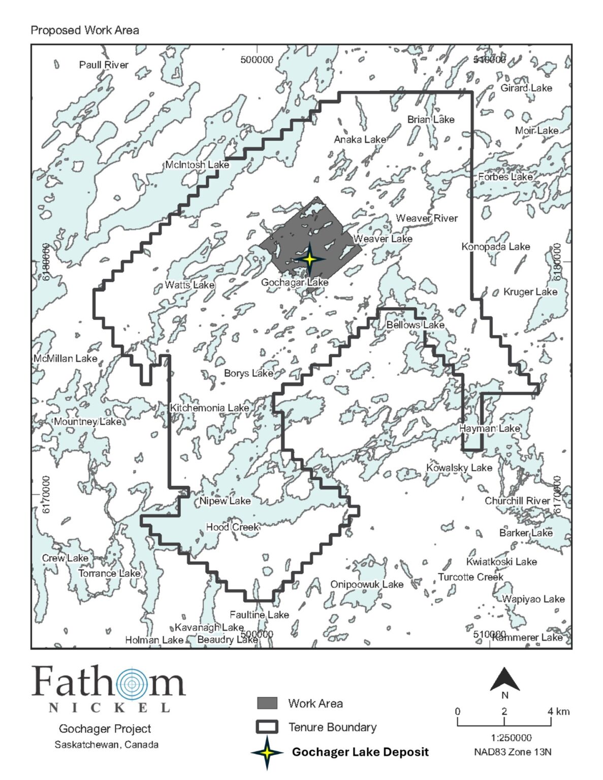
- A soil geochemical survey within the area outlined in Figure 1. The Company is confident we can define a soil geochemical signature associated with the Gochager Lake deposit and utilize this signature to expand Gochager and find additional Gochager-like deposits.
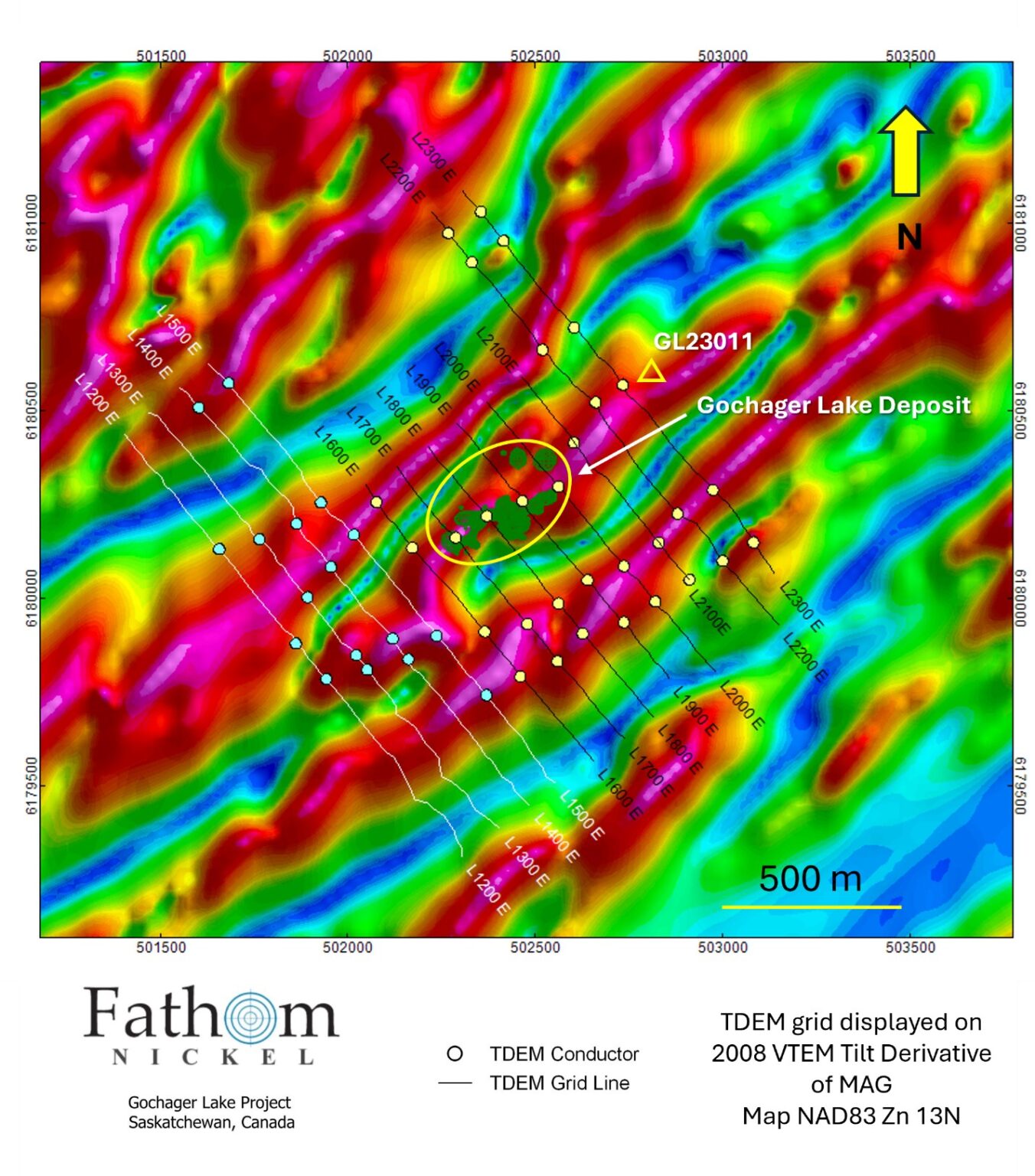
- Detailed mapping, prospecting and soil geochemical sampling will occur in areas of conductivity defined through surface time domain electromagnetic surveys (“TDEM”) performed in 2023-2024 (Figure 2). The team will focus on identifying and mapping the strike extent of the favourable gabbro host-rock and defining other favourable gabbro rock outside of the historic deposit area.
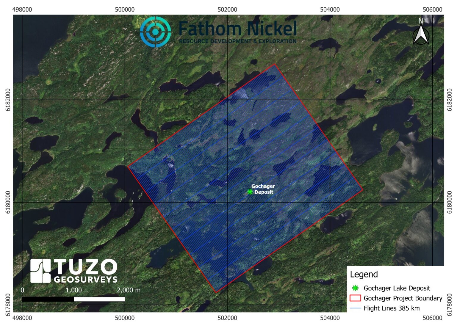
- Flying a detailed drone-MAG survey (30-meter line spacing) over the historic Gochager Lake deposit area depicted in Figure 3. The total MAG survey will encompass approximately 385 line-km.
- Field crews are expected to complete the field program by June 30, 2024.
Ian Fraser, CEO and VP Exploration stated, “We are very pleased to now have the exploration permit in hand. Having completed 16 successful drillholes in little more than a year, this two-year permit is the next step in our exploration plan to aggressively drill the historic Gochager Lake deposit and to continue to expand the deposit to depth and along strike. We expect that camp construction will begin in the coming weeks.”
Mr. Fraser continued, “There is very good geophysical evidence that the Gochager Lake deposit is potentially only the first of several magmatic nickel sulphide deposits occurring within the 22,000-hectare Gochager Lake property. Our international geophysical team have identified 13 high priority targets through the re-interpretation of the 2008 VTEM survey. During the current program, the field crews will systematically map and prospect the deposit area to further enhance our understanding of the geological, structural, geophysical and geochemical signatures of the Gochager Lake deposit. The knowledge gained from this exercise will be invaluable as we progress our exploration efforts outwards from the deposit area and start to assess the 13 other high priority targets. We are very confident that the high-resolution drone-MAG survey, combined with field mapping, will define the extent of the mineralized gabbro unit that is host to the zones of high-grade nickel mineralization along strike beyond our current drilling. Knowing the extent and the boundaries of the host gabbro unit will be critical as we prepare for a late summer/early fall drill program. We are also confident the MAG survey will map other zones of gabbro within the survey area”.
The drone-MAG survey will provide much higher resolution MAG data in comparison to the VTEM survey completed in 2008. Drone-MAG data will be flown at 30m line spacing compared to 100-200m VTEM line spacing. The Drone-MAG data will be collected from approximately 30-35 meters above surface compared to 60-65m collection height of the 2008 VTEM data. The Company has awarded the contract to Tuzo Geosurveys and looks forward to working with and interpreting this high-resolution data set in the historic Gochager Lake deposit area. We are confident this type of survey will prove very useful in our quest to define the extent of the gabbro host-rock at the Gochager deposit as well as, going forward, discover other magmatic nickel sulphide deposits within the 22,000-hectare Gochager Lake property. High-resolution data provides a clearer picture of the magnetic properties of the various intrusive rocks at Gochager and we expect to better define the magnetic properties associated with the high-grade Ni-Cu-Co bearing semi-massive to massive sulphides we have intersected by drilling.

Figure 1 – Gochager Lake Property Map, 2024 Field Activity Map
To view an enhanced version of this graphic, please visit:
https://images.newsfilecorp.com/files/7843/213705_13279f5a64ab9b6a_001full.jpg

Figure 2 – Fathom 2023-2024 TDEM Survey Area
To view an enhanced version of this graphic, please visit:
https://images.newsfilecorp.com/files/7843/213705_13279f5a64ab9b6a_002full.jpg
Figure 2 Notes:
- The Tilt Derivative is a mathematical function routinely applied to magnetic field data to preferentially enhance weaker magnetic signals to map textures, structures, and edge contacts of magnetic sources.
- The yellow polygon depicted in Figure 2 illustrates the location of the historic Gochager Lake deposit. Fathom has defined continuity of the prospective mineralized gabbro, and zones of high-grade Ni-Cu-Co mineralization along strike 230m, and to a depth of 400m.
- Drillhole GL23011, located approximately 350m northeast of the deposit area, intersected mineralized gabbro with anomalous Ni-Cu-Co and, importantly, detected significant off-hole BHEM anomalies.
- The TDEM survey(s) (yellow, blue dots) recognized conductivity associated with:
- The historic Gochager Lake deposit.
- Along strike to the northeast of the deposit area towards GL23011.
- Discrete areas of conductivity to the north and northwest of the deposit.
- Significant, and several areas of conductivity to the south and southwest of the deposit.
- The area to the southwest coincides with a fold hinge, or closure as defined by the Tilt Mag Derivative. Structural traps: in this case an interpreted fold hinge, provide excellent mechanisms to trap and concentrate magmatic sulphides.
Field crews will map, prospect and increase the density of soil sampling within these zones of conductivity.

Figure 3 – Tuzo Geosurveys Drone-MAG Survey Area
To view an enhanced version of this graphic, please visit:
https://images.newsfilecorp.com/files/7843/213705_13279f5a64ab9b6a_003full.jpg
Qualified Person and Data Verification
Ian Fraser, P.Geo., CEO, VP Exploration and a Director of the Company and the “qualified person” as such term is defined by National Instrument 43-101, has verified the data disclosed in this news release, and has otherwise reviewed and approved the technical information in this news release on behalf of the Company.
About Fathom Nickel Inc.
Fathom is an exploration company that is targeting magmatic nickel sulphide discoveries to support the rapidly growing global electric vehicle market.
The Company now has a portfolio of two high-quality exploration projects located in the prolific Trans Hudson Corridor in Saskatchewan: 1) the Albert Lake Project, a 90,000+ hectare project that was host to the historic and past producing Rottenstone deposit (produced high-grade Ni-Cu+PGE, 1965-1969), and 2) the 22,000+ hectare Gochager Lake Project that is host to a historic, NI43-101 non-compliant open pit resource consisting of 4.3M tons at 0.295% Ni and 0.081% Cu1.
1 – The Saskatchewan Mineral Deposit Index (SMID#0880) reports drill indicated reserves at the historic Gochager Lake Deposit of 4,262,400 tons grading 0.295% Ni and 0.081% Cu mineable by open pit. Fathom cannot confirm the resource estimate, nor the parameters and methods used to prepare the reserve estimate. The estimate is not considered NI43-101 compliant and further work is required to verify this historical drill indicated reserve.
ON BEHALF OF THE BOARD
Ian Fraser, CEO & Vice President Exploration
1-403-650-9760
Email: [email protected]
or
Matthew Mickleborough, Investor Relations
1-306-531-3644
Email: [email protected]
Forward-Looking Statements:
This news release contains “forward-looking statements” that are based on expectations, estimates, projections and interpretations as at the date of this news release. Forward-looking statements are frequently characterized by words such as “plan”, “expect”, “project”, “seek”, “intend”, “believe”, “anticipate”, “estimate”, “suggest”, “indicate” and other similar words or statements that certain events or conditions “may” or “will” occur, and include, without limitation, statements regarding payment of terms under the Option Agreement, permitting for the Property, receipt of an exploration permit, timing of the exploration program on the Property and the Company achieving the earn-in thresholds under the Option Agreement. Forward-looking statements relate to information that is based on assumptions of management, forecasts of future results, and estimates of amounts not yet determinable. Any statements that express predictions, expectations, beliefs, plans, projections, objectives, assumptions or future events or performance are not statements of historical fact and may be “forward-looking statements.” Forward-looking statements are subject to a variety of risks and uncertainties which could cause actual events or results to differ from those reflected in the forward-looking statements, including, without limitation: risks related to failure to obtain adequate financing on a timely basis and on acceptable terms; risks related to the outcome of legal proceedings; political and regulatory risks associated with mining and exploration; risks related to the maintenance of stock exchange listings; risks related to environmental regulation and liability; the potential for delays in exploration or development activities or the completion of feasibility studies; the uncertainty of profitability; risks and uncertainties relating to the interpretation of drill results, the geology, grade and continuity of mineral deposits; risks related to the inherent uncertainty of production and cost estimates and the potential for unexpected costs and expenses; results of prefeasibility and feasibility studies, and the possibility that future exploration, development or mining results will not be consistent with the Company’s expectations; risks related to commodity price fluctuations; and other risks and uncertainties related to the Company’s prospects, properties and business detailed elsewhere in the Company’s disclosure record. Such forward looking statements involve known and unknown risks, uncertainties and other factors which may cause the actual results, performance or achievements of the Company to be materially different from any future results, performance or achievements expressed or implied by such forward-looking statements. These forward-looking statements are made as of the date hereof and the Company does not assume any obligation to update or revise them to reflect new events or circumstances except in accordance with applicable securities laws. Actual events or results could differ materially from the Company’s expectations or projections.
NOT FOR DISTRIBUTION TO UNITED STATES NEWSWIRE SERVICES OR FOR DISSEMINATION IN THE UNITED STATES. ANY FAILURE TO COMPLY WITH THIS RESTRICTION MAY CONSTITUTE A VIOLATION OF U.S. SECURITIES LAWS